 Geography & Climate...

 Click here for a "Question about the Realities"...
Getting to Türkiye...
Click here for "Getting to Türkiye"...
You can get to Türkiye by air, rail, road or sea. Most international flights arrive at Istanbul's
"Atatürk Airport", the country's largest and busiest with a big new terminal. Most foreign visitors
arrive in Istanbul because it has the most flights and is also the first place tourists want to see.
Izmir has its shiny new "Menderes Airport" south of the city on the road to Ephesus. Antalya and Dalaman
receive mostly charter flights filled with vacationers headed for the south coast. Turkish Airlines
("Türk Hava Yollari"), flight symbol TK has flights to New York, Singapore, most major cities in
Europe, the Middle East and Africa. The airlines of these destination countries also fly into and out
of Türkiye.

 Click on the thumbnail for the web site of "Turkish Airlines"...
Click on the thumbnail for the modern fleet of "Turkish Airlines"...
 Click here for "How to Visit ?" - Link # 1...
Distances...
Türkiye is big : the distance by road from Edirne on the Bulgarian border to Kars on the
Russian one is over 1,700 km. From the Black Sea shore to the Mediterranean is almost 1,000 km.
Now, 1,000 km on flat ground might take only one very long day to drive, but Türkiye has many
mountain ranges which can lengthen travel times considerably.
Click here for "How to Visit ?" - Link # 2...
Geographic Info...
Most first - time visitors come to Türkiye expecting to find deserts, palm trees and camel
caravans. In fact, the country is geographically diverse, with snow - capped mountains,
rolling steppe, broad rivers, verdant coasts and rich agricultural valleys. It's interesting
to note that Ankara, the country's capital, is at a latitude similar to those of Naples,
Lisbon, Eeijing and Philadelphia. The southernmost shore of Türkiye is similar in latitude
to Tokyo, Seoul, Gibraltar, Norfolk (USA) and San Francisco.
Horizontal Areas...
| Region |
Area ( km2 ) |
| Eastern Anatolian |
171,000 |
| Central Anatolian |
162,000 |
| Blacksea Anatolian |
146,178 |
| Mediterranean Anatolian |
122,100 |
| Aegean Anatolian |
85,000 |
| Marmara Anatolian |
67,300 |
| Southeastern Anatolian |
61,000 |
| Total |
814,578 |
Türkiye is located between 35 deg and 42 deg north latitude, and 25 deg and 44 deg east
longitude. It covers an area of 779,452 square km, and has borders with Bulgaria, Greece,
Iran, Iraq, Syria and the Soviet Union (former). Its coastline totals almost 8,400 km; the
Aegean coastline alone is 2,800 km long. As for mountains, the highest is Agri Dagi (Mt.
Ararat) at 5,165 m (17,275 feet). Uludag (Mt. Olympus) near Bursa is 2,543 m (8,343 feet).
Under the empire, snow and ice could be taken from Uludag, sailed across the Sea of Marmara,
and presented to the sultan in Istanbul to cool his drinks.
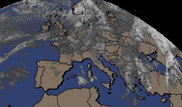
Click here for "Local Times Around the World"...
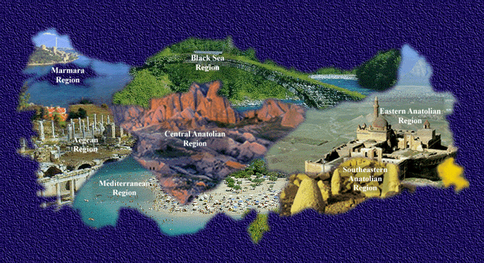
Climatic Regions...
Going from west to east, here's the lay of the land :
Marmara : This region includes eastern Thrace from Edirne to Istanbul, rolling
steppe and low hills good for grazing, some farming and industry. The peninsula of Gelibolu
(Gallipoli) forms the north shore of the Canakkale Bogazi (Dardanelles). On the southern shore
of the Sea of Marmara are low hills and higher mountains (including Uludag). The land is very
rich, excellent for raising fruits such as grapes, peaches and apricots. The average rainfall
is about 670 mm; this is Türkiye's second most humid region, with an annual average of 73%
humidity.
Aegean : This is a region of fertile plains and river valleys, low hills and
not - so - low mountains. The ancient river Meander, now called the Menderes, is a good
example of the Aegean's rivers. When you see it from the heights of ruined Priene, you'll
know where the word "meander" comes from. For travelling, the Aegean region presents constantly
changing views of olive, fig and fruit orchards on hillsides; and broad tobacco and sunflower
fields in the valleys.
Mediterranean : The Mediterranean coast is mountainous without much beach
between Fethiye and Antalya, but then opens up into a fertile plain between Antalya and Alanya
before going to mountains again. All along the south coast, mountains loom to the north. The
great Taurus (Toros) range stretches all the way from Alanya east to Adana. Temperatures at
Antalya are a few degrees warmer than at Izmir.
Central Anatolia : The Turkish heartland is a vast high plateau broken by mountain ranges,
some being volcanoes with snowcapped peaks. The land is mostly rolling steppe good for growing
wheat and grazing sheep. Ankara's elevation is 900 metres above sea level. In summer, Ankara
is hot and dry; in winter, chilly and often damp. Late spring and early autumn are perfect.
Black Sea : The coast, 1,700 km long, has a climate you might not expect in this
part of the world. Rainfall is two to three times the national average, and temperatures are
moderate. You will see hazelnut groves, cherry orchards and tobacco fields. The root word of
"cherry" is the Latin cerasus (Turkish kiraz), and this is where they came from, getting their
name in Roman times. The cattle on the outskirts of every town provide milk, cream and butter
famous throughout Türkiye. At the eastern end of the Black Sea coast, the mountains come right
down to the sea, and the slopes are covered with tea plantations. Rainfall and humidity are
highest here. All in all, the Black Sea coast is like central Europe, but pleasantly warmer.
South - East Anatolia : This region is dry (382 mm rainfall per year) and very
hot in summer, as hot as 47 deg C. The land is rolling steppe with rock outcrops. The major
rivers are the Tigris (Dicle) and the Euphrates (Firat), both of which spring in Türkiye. In
the next few years, the mammoth South - East Anatolia Project (GAP) will come on line,
completely, providing irrigation to thousands of hectares of farmland and millions of
kilowatt - hours of electricity for industry. Huge new lakes will be formed and new
recreational facilities built. All of this activity is being changed the face of this historically
poor region, making it among the most prosperous in the country.
Eastern Anatolia : A mountainous zone, this is wildly beautiful like no other
region in Türkiye. The average temperature is a cool 9 deg C, but varies between a hot 38 deg C
and a daunting - 43 deg C. Rainfall is average for Türkiye, about 560 mm. It's cold out here
except from June to September. The people are not as rich as in other regions, but they do
well enough grazing sheep, raising wheat and producing a few other crops.
When to Visit...
Spring and autumn are best, roughly from April to June and September to October. The climate
is perfect on the Aegean and Mediterranean coasts then, and in Istanbul. It's cooler in Central
Anatolia, but not unpleasantly so. Normally, there is little rain between May and October
except along the Black Sea coast.
The best months for water sports are, of course, the warmest: July and August. But the water
is just right in May, June, September and October too. In the hottest months on the coasts you
may have to take a siesta during the heat of the day between 12 noon and 3 pm. Get up early in
the morning, clamber around the local ruins, then after lunch and a siesta come out again for
piyasa vakti, "promenade time", when everyone strolls by the sea, sits in a cafe, and
watches the sunset.
If you plan a trip to eastern Türkiye, do it in late June, July or August. As a general rule,
you should not venture into the east before June or after September unless you're prepared, as
there will still be lots of snow around, perhaps even closing roads and mountain passes.
Unfortunately, the trip to eastern Türkiye in high summer usually includes a pass through the
south - east, which is beastly hot at that time.
Click here for "Today's Temperatures of all Cities of Türkiye"...
The following chart shows the average daily minimum and maximum temperatures (in deg C) for the
main centres in Türkiye.
|
City
|
January
|
March
|
May
|
July
|
September
|
November
|
| Ankara |
-4 - 4 |
0 - 11 |
9 - 22 |
15 - 30 |
11 - 26 |
2 - 13 |
| Antalya |
6 - 15 |
8 - 18 |
15 - 25 |
23 - 34 |
19 - 31 |
11 - 21 |
| Bursa |
2 - 9 |
4 - 13 |
11 - 23 |
17 - 31 |
14 - 27 |
7 - 16 |
| Edirne |
-1 - 6 |
2 - 12 |
12 - 24 |
17 - 31 |
13 - 27 |
5 - 13 |
| Istanbul |
3 - 8 |
3 - 10 |
12 - 21 |
18 - 29 |
16 - 25 |
9 - 15 |
| Izmir |
5 - 12 |
6 - 16 |
14 - 26 |
21 - 33 |
17 - 29 |
10 - 29 |
| Trabzon |
5 - 11 |
5 - 11 |
13 - 17 |
20 - 26 |
18 - 23 |
10 - 16 |

Click on the logo for the "Latest Temperatures - 1"...

Click on the logo for the "Latest Temperatures - 2"...