| Yozgat... |
|
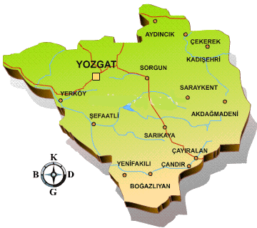
217 km from Ankara, is Yozgat, the history of which extends as far back as the Hittite period. It was an important
residential area in those times, and Alisar, one of the main Hittite cities, lies inside the borders of this province.
Bogazkoy and Alacahoyuk, though not being part of Yozgat, are near enough to reflect the central position of the site
then, with notable ruins found in the district. Today's city of Yozgat, on the other hand, is rather new, founded in
the 18th century by the Ottomans. Capanoglu Ahmet Pasa, who was the "Bey" of the Turkmens at that
time was the founder; and the Capanoglu Mosque which carries his name, stands as a remain of this period together with
the Suleyman Bey Mosque. Constructed in the 19th century, the Nizamoglu Mansion is a prominent building,
presenting fine Turkish architectural style. It is an important house of the Ottoman period and is now used to exhibit
ethnographical finds. Near Yozgat, "Camlik" is an islet of forests. This site is a national park, 5 km south
of the city, and it adorns the land with its beautiful scenery. The old main road, a block north of the highway, is more
sympathetic than the highway, "Ankara Caddesi". Walk two blocks north to reach the main square, "Cumhuriyet Meydani", with
its old clock tower, "Vilayet" building, Türk - Telecom and an old Ottoman building now serving as local army offices; the
sultan's monogram is still emblazoned in the tympanum. The "Büyük Cami" (or Capanoglu Camii, 1778) one long block west of
the clock tower, is a late Ottoman work. Yozgat's otogar is less than one km east of the main square, an easy walk. To
find your way to the main square from the otogar, go out the front door and turn right. Five km south of Yozgat is "Camlik
Milli Parki". Ortakoy is a town 53 kms. southeast of the province of Corum in central Türkiye. It is situated at the north
of Central Anatolia, to the south of Black Sea Mountain Range and at the end of Kelkit Valley which is the entrance to
Anatolia from the Caucasus. To the east lies Amasya, and to the southwest, Yozgat. Shapinuwa is situated 3 kms. southwest
of Ortakoy. It can be reached, as well as with the highway from Corum, either with Sungurlu-Alaca-Kizilli-Ortakoy route or
with Amasya-Goynucek route. Excavations at Ortakoy - Shapinuwa, having been localized in a survey in 1989, first started
in 1990 on behalf of Ankara University with the permission of Ministry of Culture of the Republic of Türkiye.
|
|

|


 354...
 66...
66...
 682,919...
 14,123...
 34 E 48 - 39 N 50...


