The Global Oceanic Heat Budget...
The oceanic heat budget consists of inputs and outputs. "Input" identifies a process through which the ocean gains heat,
while "output" represents a heat loss to the ocean. A complete list of all inputs and outputs is as follows (
 ) ; + indicates input or heat gain, - signifies output or heat loss : (1) Primary inputs and outputs : (a) radiation
from the sun (+), (b)long-wave back radiation (-), (c) direct heat transfer air/water (transer of sensible heat) (-; + when
from air to water), (d) evaporative heat transfer (-; + when condensation; this situation occurs very rarely, mainly during
sea fog conditions), (e) advective heat transfer (currents, vertical convection, turbulence) (- or +); this effect cancels
on the global scale or in closed basins; (2) Secondary sources : (a)heat gain from chemical/biological processes (+),
(b) heat gain from the earth's interior and hydrothermal activity(+), (c) heat gain from current friction (+), (d) heat gain
from radioactivity (+). The contributions from secondary sources are negligible for most applications. The following discussion
addresses only the primary inputs and outputs.
Heat Budget Inputs...
Solar Radiation...
Energy from the sun at the outer limit of the atmosphere at normal incidence amounts to 2.00 cal / cm2 . min
(the "solar constant"). Variations in the intensity of the incoming radiation are of regular and irregular character.
Seasonally the solar radiation varies between zero and 1100 cal / cm2 . day at the poles and 800 - 900 cal /
cm2 . day at the equator. Maximum interannual variations arise from the variation of the distance between the
earth and the sun and amount to 3.34%; they can be predicted and explain the major climate changes over geological time. In
the modern literature the unit cal / cm2 . day (calories per square centimeter per day) has been replaced by the
unit W / m2 (Watts per square meter). The translation between units is achieved by noting that 1 calorie (cal) =
4.184 Joules (J) and 1 Watt (W) = 1 Joule per second (J / sec). This gives a conversion factor of 1 cal / cm2 . day
= 0.484 W / m2. In other words, a heat input of 1,000 cal / cm2 . day converts roughly to 500 W /
m2.
) ; + indicates input or heat gain, - signifies output or heat loss : (1) Primary inputs and outputs : (a) radiation
from the sun (+), (b)long-wave back radiation (-), (c) direct heat transfer air/water (transer of sensible heat) (-; + when
from air to water), (d) evaporative heat transfer (-; + when condensation; this situation occurs very rarely, mainly during
sea fog conditions), (e) advective heat transfer (currents, vertical convection, turbulence) (- or +); this effect cancels
on the global scale or in closed basins; (2) Secondary sources : (a)heat gain from chemical/biological processes (+),
(b) heat gain from the earth's interior and hydrothermal activity(+), (c) heat gain from current friction (+), (d) heat gain
from radioactivity (+). The contributions from secondary sources are negligible for most applications. The following discussion
addresses only the primary inputs and outputs.
Heat Budget Inputs...
Solar Radiation...
Energy from the sun at the outer limit of the atmosphere at normal incidence amounts to 2.00 cal / cm2 . min
(the "solar constant"). Variations in the intensity of the incoming radiation are of regular and irregular character.
Seasonally the solar radiation varies between zero and 1100 cal / cm2 . day at the poles and 800 - 900 cal /
cm2 . day at the equator. Maximum interannual variations arise from the variation of the distance between the
earth and the sun and amount to 3.34%; they can be predicted and explain the major climate changes over geological time. In
the modern literature the unit cal / cm2 . day (calories per square centimeter per day) has been replaced by the
unit W / m2 (Watts per square meter). The translation between units is achieved by noting that 1 calorie (cal) =
4.184 Joules (J) and 1 Watt (W) = 1 Joule per second (J / sec). This gives a conversion factor of 1 cal / cm2 . day
= 0.484 W / m2. In other words, a heat input of 1,000 cal / cm2 . day converts roughly to 500 W /
m2.
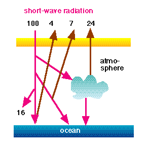
Not all of the radiation received at the outer atmosphere is available to the ocean. If the incoming radiation is normalised
to 100%, then 16% are absorbed in the atmosphere, 24% are reflected by clouds, 7% are radiated back to space from the atmosphere,
4% are reflected from the earth's surface (mainly from the sea). Thus, 35% returns into space, while 65% are available as energy.
(The equivalent of 16% is stored in the atmosphere and therefore available eventually.)
The incoming radiation is emitted from the sun at ~6,000 K (Kelvin, equivalent to the Celsius scale but with a shift in
scale such that 0°C corresponds to 273 K). According to Wien's Law, maximum radiation occurs at a wavelength given by
l = 2,897 (T - 1)
where; T is in degrees K and l (lambda) the wavelength in micrometers. Maximum radiation from the sun therefore occurs in
the wavelength range of visible light and peaks at 0.48 micrometers, which is in the blue range. It decays rapidly towards
shorter wavelengths (in the ultraviolet or UV) and slowly towards longer wavelengths (in the infrared).
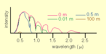
Solar energy received by the ocean varies irregularly with wavelength, as a result of absorbtion by water vapour and the
various atmospheric gases, particularly oxygen and hydrocarbon. Absorption in the sea reduces the light level rapidly with
depth (
). At vertical light incidence (i.e. most favourable conditions) ;
| Reaching ratio ( % ) |
Depth (m) |
| 73 |
0.01 |
| 44.5 |
1 |
| 22.2 |
10 |
| 0.53 |
100 |
| 0.0062 |
200 |
The minimum energy supply necessary to maintain photosynthesis is 0.003 cal / cm2 . min. Under optimum conditions
(absolutely clear water) this amount is available at 220 m depth.
Heat Budget Outputs...
Back Radiation...
Some of the radiation received from the sun is radiated back from the ocean surface. The wavelength where most of this
back-radiation occurs is again given by Wien's Law. As the temperature of the sea surface is much lower than that of the
sun (~283 K), maximum back radiation is found at 10 micrometers, i.e. in the infrared or heat radiation. According to the
Stefan-Boltzman Law, the energy of the radiation is proportional to the fourth power of the absolute temperature (temperature
expressed in K). Thus, daily or seasonal variations in the ocean's surface temperature have little effect on the back radiation
energy, since these variations are small compared to the absolute temperature level.
Direct (Sensible) Heat Transfer Between Ocean and Atmosphere...
On average, the ocean surface is about 0.8°C warmer than the air above it. Direct heat transfer (transfer of sensible heat)
therefore occurs usually from water to air and constitutes a heat loss. Heat transfer in that direction is achieved much
more easily than in the opposite direction for two reasons : (1) It takes much less energy to heat air than water. The energy
needed to increase the temperature of a layer of water 1 cm thick by 1°C is sufficient to raise the temperature of a layer
of air 31 m thick by the same amount and (2) Heat input into the atmosphere from below causes instability (through a reduction
of density at the ground) which results in atmospheric convection and turbulent upward transport of heat. In contrast, heat
input into the ocean from above increases stability (through a reduction of density at the surface) and prevents efficient
heat penetration into the deep layers.
Evaporative Heat Transfer...
51% of the heat input into the ocean is used for evaporation. In addition to the important contribution to the heat budget,
evaporation - constituting a loss of water to the atmosphere - plays an important role in the mass budget, which will be
discussed below.
Evaporation starts when the air is unsaturated with moisture. Warm air can retain much more moisture than cold air. As
under normal conditions direct heat transfer is from the sea to the air (i.e. the air is normally heated from below), the
normal situation is that the air is unsaturated with moisture and evaporation occurs. Condensation occurs where warm air
is found over cold water. Such ocean areas are known and feared for the frequent occurrence of fog. Most of the energy
released during condensation goes into the atmosphere, so the contribution of condensation to the oceanic heat budget is
extremely small. The heat budget is the balance between the terms discussed above. Normally, the first two terms are not
considered separately; the difference solar radiation minus oceanic back-radiation, or net radiative heat gain, is used as
the major input. The balance is then ;
Net radiative heat gain - Evaporative heat loss - Direct heat loss = 0
This budget is closed if the world ocean is considered. If the budget is evaluated for limited ocean regions, the right-hand
side is not usually zero but represents the heat transfer achieved by ocean currents.
gives the heat budget of the North Atlantic Ocean as an example. On the global scale,
shows the role of heat transport by currents in the heat budget in a zonal section from 60°N to 60°S. Net heat input
decreases from the tropics towards the poles; it has a weak minimum near the equator because of heavy cloud cover in that
region. The maximum of the evaporative heat loss in the subtropics is produced by atmospheric advection of dry air; the
minimum in the tropics results from high moisture content of the tropical air. Sensible heat loss is small throughout.
Currents remove heat from the tropics (this is a heat loss to the ocean - positive values) and deposit it in the subpolar
regions ( a heat gain - negative values).
The Oceanic Mass Budget...
The mass budget involves the effects of evaporation and precipitation on the amount of water in the ocean. The effect on
the total amount of water is significant only on a geological time scale. Its major importance for oceanographic applications
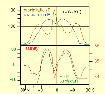
lies in its influence on the salinity in the surface layer of the ocean. The evaporation rate E, i.e. the loss of water due
to evaporation over a given time span is proportional to the distribution of evaporative heat loss. The proportionality
constant is known as the evaporation constant of water; it amounts to 585 cal / g. Precipitation P has to be taken from
observations. It is high in the Doldrums (just north of the equator) and at the Polar fronts (at about 50° latitude). The
distribution of sea surface salinity mirrors the distribution of E-P over large parts of the ocean (
). Deviations occur from river run-off. On a global scale, the balance is ;
Evaporation = 440,103 km3 / year
Precipitation = 411,103 km3 / year
River run-off = 29,103 km3 / year
The melting and freezing of ice is balanced (except on the geological time scale). Most rivers are found in the northern
hemisphere, so the proportionality between sea surface salinity and E-P is better over most of the southern hemisphere.
Note: Evaporation, precipitation and river run-off are expressed as volume per unit time. Modern oceanography uses more and
more a unit called "Sverdrup" (Sv), defined as 1 million cubic meters per second : 1 Sv = 106 m3 / sec. The
conversion factor for km3 / year to Sv is 1,000 km3 / year = 0.317 Sv. This gives an evaporation of
140 Sv, a precipitation of 131 Sv and a total river run-off of 9 Sv.
Distribution of Temperature and Salinity with Depth...
The discussion of the previous lectures concentrated on air/sea interaction processes and therefore addressed the distribution
of temperature and salinity only in the surface layer, where regional and seasonal variations are large. However, most of the
ocean is filled with water of relatively uniform temperature and salinity (
). If the surface temperature is very low, convection from cooling can reach deeper than the surface layer. This situation
is encountered in the polar regions where cold water sinks to the bottom of the ocean. This process replenishes the deeper
waters and is responsible for the currents below the upper kilometre of the ocean. Areas of deep winter convection are the
Weddell Sea and the Ross Sea in the Southern Ocean and the Greenland Sea and the Labrador Sea in the Arctic region.
The average ocean temperature is 3.8°C; even at the equator the average temperature is as low as 4.9°C. The layer where the
temperature changes rapidly with depth, which is found in the temperature range 8 - 15°C, is called the permanent thermocline.
It is located at 150 - 400 m depth in the tropics and at 400 - 1,000 m depth in the subtropics.
shows the temperature and salinity distribution in a meridional section through the Pacific Ocean as an example. Notice the
uniformity of both properties below 1,000 m depth. Notice also that in many ocean regions, temperature and salinity both
decrease with depth. A decrease in temperature results in an increase of density, so the temperature stratification produces
a stable density stratification. A decrease in salinity, on the other hand, produces a density decrease. Taken on its own,
the salinity stratification would therefore produce an unstable density stratification. In the ocean the effect of the
temperature decrease is stronger than the effect of the salinity decrease, so the ocean is stably stratified. In contrast
to the subsurface temperature distribution, the subsurface salinity distribution shows intermediate minima. They are linked
with water mass formation at the Polar Fronts where precipitation is high; details will be discussed later in the course.
At very great depth, salinity increases again because the water near the ocean bottom originates from polar regions where
it sinks during the winter; freezing during the process increases its salinity.
Acoustic Properties...
Light and sound are two principal carriers of information used in human and animal communication. On land, sound is
attenuated over much shorter distances than light, which is therefore the preferred choice for long-distance communication.
The reverse situation is found in the ocean. While light does not penetrate very far in water, sound can travel over large
distances and is therefore used for various purposes, such as depth sounding, communication, range finding and underwater
measurement, by animals and humans alike. Detailed information on the speed of sound (ie the phase velocity of the sound
waves) is essential for such applications.
The sound speed c is a function of temperature T,salinity S and pressure p and varies between 1,400 m / sec and 1,600 m / sec.
In the open ocean it is influenced by the distribution of T and p but not much by S. It decreases with decreasing T, p and
S. The combination of the variation of these three parameters with depth produces a vertical sound speed profile with a
marked sound speed minimum at intermediate depth. Temperature decreases rapidly in the upper kilometre of the ocean and
dominates the sound speed profile, i.e. c decreases with depth. In the deeper regions (below the top kilometre or so) the
temperature change with depth is small and c is determined by the pressure increase with depth, i.e. c increases with depth.
Vertical changes of salinity are too small to have an impact; but the average salinity determines whether c is low (if the
average salinity is low) or high (if the average salinity is high) on average.
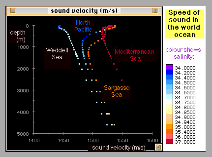
shows examples of sound speed profiles. Note the curves for the Weddell Sea and the Mediterranean Sea: The Weddell Sea does
not have a thermal stratification, hence no temperature effect on c. The Mediterranean Sea demonstrates the effect of salinity
on c. The profile is similar to those of other tropical ocean regions, but the higher salinity of the Mediterranean Sea
increases c at all levels.
Sound Propagation...
Sound propagates along rays (just as light does). Thus, the laws of geometrical optics are applicable to sound ; (1) Sound
travels along a straight path where the sound speed c is constant; it bends toward the region of lower c otherwise. (2)
Different rays are independent of each other. (3) Sound paths are reversible. (4) The law of reflection (angle of incidence ,
angle of reflection) holds at the sea floor, surface, at objects and interfaces. (5) The law of refraction holds at interfaces.
As the stratification in the ocean is nearly horizontal, sound propagation in the vertical is practically along a straight
path. This is the basis for echo sounding. The depth is known if the mean sound velocity is known. A first estimate is 1,500
m / sec; available tables list corrections for the various areas of the world ocean.
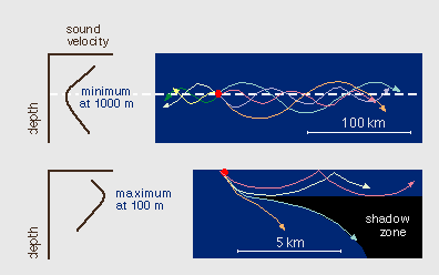
gives examples of horizontal sound paths. The first diagram shows sound propagation at the depth of the sound speed minimum
(usually about 1,000 m). Sound rays bend back towards the depth of minimum sound speed and travel at that depth over large
distances (they can traverse entire oceans). This sound channel is known as the SOFAR (SOund Fixing And Ranging) channel.
Before the introduction of the Global Positioning System (GPS) the SOFAR channel was used to locate ships and aircraft in
distress, and for tracking floats (with two or more receivers) for the study of ocean currents. The second diagram shows a
situation where a mixed layer of uniform temperature (typically about 100 m thick) is found on top of the normal temperature
stratification. In this case sound speed increases below the surface due to the increase in pressure before the normal decrease
due to temperature takes over. The resulting sound speed maximum at about 100 m depth creates a shadow zone, since all sound
rays bend away from that depth.
Nutrients and Oxygen in the Ocean...
Justus von Liebig discovered what has become known as the "Minimum Law" of agriculture, that ecosystem productivity is
limited by the nutrient which is exhausted first. On land the limiting element is either phosphorus, nitrogen or potassium
(depending on soil type). In the ocean the limiting elements are phosphorus (as organic or anorganic phosphate), nitrogen
(as nitrate, nitrite, and ammonia), silicon (as silicate). On land nutrients enter the soil by decomposition of dead organic
matter. In the ocean nutrient uptake by plants (phytoplankton) occurs in the euphotic zone (the surface layer reached by
sunlight) where photosynthesis takes place. Most nutrients are removed from the euphotic zone and transferred to the deeper
ocean as dead organisms (detritus) sink to the ocean floor. In the deeper layers organic matter is remineralized, ie nutrients
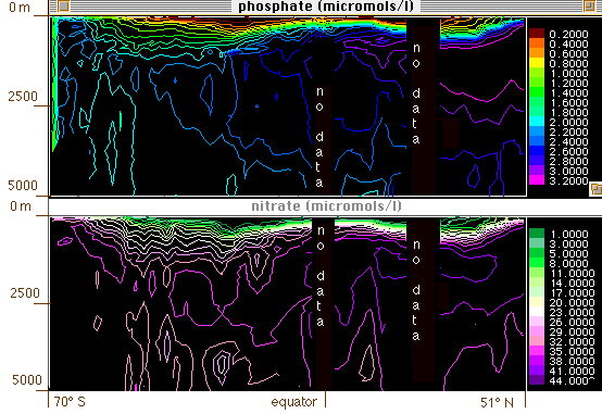
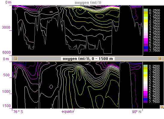
are brought back into solution. This process requires oxygen. Thus, the ocean cannot support highly productive ecosystems
except where nutrients are returned to the euphotic zone from below (upwelling) nutrient concentrations usually increase
with depth (
), while oxygen concentration (
) decreases. Departures from this rule are caused by advection of different water. Oxygen and nutrients are linked in a
cycle of uptake and release, so a fixed ration of their concentrations is found in open ocean water. AOU : C : N : P =
212 : 106 : 16 : 1 on atomic weight = 109 : 41 : 7.2 : 1 in grams. Where ; AOU (apparent oxygen utilisation) = saturation
concentration - observed concentration, C = carbon, N = nitrogen, P = phosphorus.
Aspects of Geophysical Fluid Dynamics...
Equation which describes motion in the ocean is derived from Newton's Law, which expresses conservation of momentum in
the form force = mass times acceleration, or
F = (m) (a)
In fluids this equation is expressed in terms of forces per unit mass F', so that
F' = dv / dt
where v = (u,v,w) is the velocity in component notation along the axes x,y,z with x pointing east, y north and z downward
(a = dv / dt is the acceleration). If there is more than one force, Newton's Law establishes the principle of equilibrium
between the forces involved. The law applies in an absolute co-ordinate system, ie a system which is either stationary or
moving at constant speed. Co-ordinate systems in oceanography are usually defined with their origin somewhere on the earth's
surface (for example at the north pole). They are therefore neither stationary nor moving at constant speed but rotate with
the Earth. If Newton's Law is expressed in a rotating coordinate system, it must include an apparent or virtual force which
takes care of the effect of rotation.
Classification of Forces for Oceanography...
Forces generating currents : (1) External forces (exerted on the fluid boundaries) ; (a) tangential stress (wind)
(b) effects of thermo-haline driving (surface cooling, evaporation etc.). Strictly speaking, surface cooling and evaporation
are not forces as such but lead to changes of density which translate into changes of the pressure field. (2) Internal forces
(exerted on all water particles) ; (c) Interior pressure field (pressure gradient), (d) Tidal forces.
Forces retarding currents : (1) Friction (diffusion of momentum), (2) Diffusion of density (results in a change of
pressure gradient).
Forces (1 - a) and (1 - b) act only at the boundaries; mathematically, they determine the boundary conditions of the
geophysical problem but do not enter the equation of motion. Force (2 - a) acts on all water particles and is therefore
part of the equation of motion (it is one of the forces in Newton's force balance). Force (2 - b) is not acting on water
motion directly but changes the temperature and salinity fields and therefore the density; its effect is felt through the
pressure field.
Newton's Law in Oceanography ("Equation of Motion")...
By balancing all forces acting in the ocean Newton's Law takes the form ;
Particle acceleration = - Pressure gradient + Coriolis force + Tidal force per unit mass + Friction + Gravity
The tidal force needs only be considered in tidal problems; it can be ignored in a discussion of the general oceanic circulation.
Gravity does not exert a horizontal force and thus cannot produce horizontal acceleration; it is important in movement which
involves vertical motion (convection, waves).Why the negative sign for the pressure gradient? Because flow produced by a pressure
gradient is directed down the gradient: pressure p increases with increasing distance x (to the right), the pressure gradient is
positive, current flows from high pressure to low pressure (down the pressure gradient, to the left).
The Coriolis force is an apparent force, that is, it is only apparent to an observer in a rotating frame of reference. To
see this, consider a person standing on a merry-go-round, facing a ball thrown by a person from outside. To follow the ball
the person would have to turn and therefore conclude that a force must be acting on the ball to deflect it from the shortest
(straight) path. The person throwing the ball sees it follow a straight path and thus does not notice the force, and indeed
the force does not exist for any person not on the merry-go-round. In oceanography currents are always expressed relative
to the ocean floor - which rotates with the earth - and can therefore only be described correctly if the Coriolis force is
taken into account in the balance of forces. The Coriolis force is proportional in magnitude to the flow speed and directed
perpendicular to the direction of the flow. It acts to the left of the flow in the southern hemisphere and to the right in
the northern hemisphere. A somewhat inaccurate but helpful way to see why the direction is different in the two hemispheres
is related to the principle of conservation of angular momentum.
A water particle at rest at the equator carries angular momentum from the earth's rotation. When it is moved poleward it
retains its angular momentum while its distance from the earth's axis is reduced. To conserve angular momentum it has to
increase its rotation around the axis, just as ballet dancers increase their rate of rotation when pulling their arms
towards their bodies (bringing them closer to their axis of rotation). The particle therefore starts spinning faster then
the earth below it, ie it starts moving eastward. This results in a deflection from a straight path towards right in the
northern hemisphere and towards left in the southern hemisphere. Likewise, a particle moving toward the equator from higher
latitudes increases its distance from the axis of rotation and falls back in the rotation relative to the earth underneath;
it starts moving westward, or again to the right in the northern and to the left in the southern hemisphere.
Inertial Motion...
If a water parcel is given some momentum (pushed) and then left to its own devices, the only force acting on it is the
Coriolis force. Newton's Law then states that the parcel will accelerate at a constant rate. Since the acceleration is
produced by the Coriolis force it is directed perpendicular to the parcel's path; in other words, the acceleration takes
the form of a constant change of direction. The result is that the parcel moves on a circle. Inertial motion is very common
in the ocean, where it is usually found superimposed on other movement (such as geostrophic or wind-driven flow discussed
below).
gives an example from the Baltic Sea.
Geostrophic Flow...
In the ocean interior, ie below about 100 m depth and about 100 km away from coastlines, frictional forces can be neglected.
The steady state circulation is then determined by the balance between the pressure gradient force and the Coriolis force.
This balance is known as geostrophic flow. In geostrophic flow particles move along isobars (contours of constant pressure),
with high pressure on their left in the southern hemisphere, on their right in the northern hemisphere. Since the pressure at
any depth is determined by the weight of the water above, high and low pressure are equivalent to high sea level and low sea
level. Geostrophic flow is therefore related to the shape of the sea surface.
shows an example of geostrophic flow in the equatorial current system. Note that the variations in sea level are only of
the order 0.2 - 0.4 m. These small variations are impossible to verify in the open ocean. They have, however, been varified
in narrow straits, where a reversal of the current flowing through the strait produces a reversal of the sea surface tilt
across the strait. The tilt can be measured with sea level gauges on both sides. Another important aspect of geostrophic
flow relates to the circulation around eddies.
shows the principle. It applies equally to oceanic and atmospheric eddies and explains why a high pressure system to the
east of Adelaide in South Australia brings northerly winds.
The Ekman Layer...
Currents in the upper 150 m or so of the ocean are directly affected by the wind, ie transfer of momentum from the
atmosphere to the ocean. The balance of forces therefore involves frictional forces, which cause a departure from
geostrophic flow; water moves across isobars from areas of high pressure to areas of low pressure. The layer over which
the flow is non-geostrophic is known as the Ekman layer. The direction of water movement in the Ekman layer varies with
depth. The details are complicated (
); but an important result of the balance of forces is that the net (ie vertically averaged) transport in the Ekman layer
is directed perpendicular to the wind direction, to the left in the southern hemisphere and to the right in the northern
hemisphere.
Upwelling...
(1) Coastal upwelling : Along the eastern coasts of the Pacific and Atlantic Oceans the Trade Winds blow nearly
parallel to the coast towards the Doldrums. The Ekman transport is therefore directed offshore, forcing water up from
below (usually from 200 - 400 m depth;
).
(2) Equatorial upwelling : In the Pacific and Atlantic Oceans the Doldrums are located at 5°N, so the southern
hemisphere Trade Winds are present on either side of the equator. The Ekman layer transport is directed to the south in
the southern hemisphere, to the north in the northern hemisphere. This causes a surface divergence at the equator and
forces water to upwell (from about 150 - 200 m).
(3) Upwelling in the Southern Ocean : North Atlantic Deep Water reaches the Southern Ocean in a broad flow in the
depth range 1,000 - 4,000 m. It rises to within 200 m of the surface, to enter the circulation of the upper layers. This
rise over more than 2,000 m is the deepest upwelling process in the World Ocean.


 ) ; + indicates input or heat gain, - signifies output or heat loss : (1) Primary inputs and outputs : (a) radiation
from the sun (+), (b)long-wave back radiation (-), (c) direct heat transfer air/water (transer of sensible heat) (-; + when
from air to water), (d) evaporative heat transfer (-; + when condensation; this situation occurs very rarely, mainly during
sea fog conditions), (e) advective heat transfer (currents, vertical convection, turbulence) (- or +); this effect cancels
on the global scale or in closed basins; (2) Secondary sources : (a)heat gain from chemical/biological processes (+),
(b) heat gain from the earth's interior and hydrothermal activity(+), (c) heat gain from current friction (+), (d) heat gain
from radioactivity (+). The contributions from secondary sources are negligible for most applications. The following discussion
addresses only the primary inputs and outputs.
) ; + indicates input or heat gain, - signifies output or heat loss : (1) Primary inputs and outputs : (a) radiation
from the sun (+), (b)long-wave back radiation (-), (c) direct heat transfer air/water (transer of sensible heat) (-; + when
from air to water), (d) evaporative heat transfer (-; + when condensation; this situation occurs very rarely, mainly during
sea fog conditions), (e) advective heat transfer (currents, vertical convection, turbulence) (- or +); this effect cancels
on the global scale or in closed basins; (2) Secondary sources : (a)heat gain from chemical/biological processes (+),
(b) heat gain from the earth's interior and hydrothermal activity(+), (c) heat gain from current friction (+), (d) heat gain
from radioactivity (+). The contributions from secondary sources are negligible for most applications. The following discussion
addresses only the primary inputs and outputs.
 ). At vertical light incidence (i.e. most favourable conditions) ;
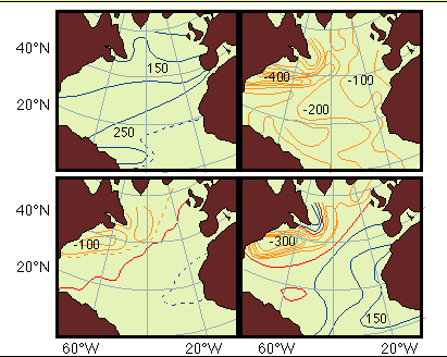 gives the heat budget of the North Atlantic Ocean as an example. On the global scale,
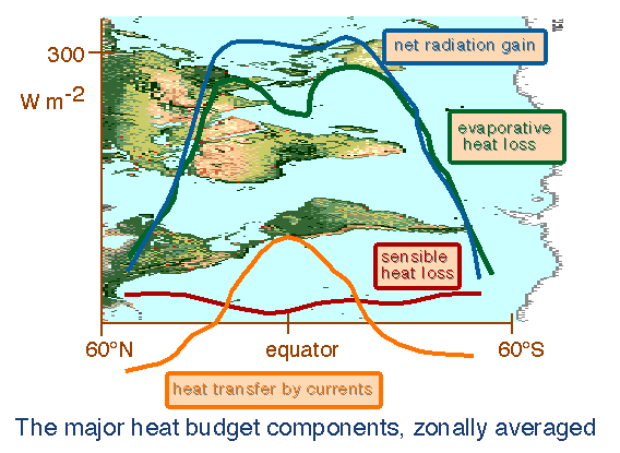 shows the role of heat transport by currents in the heat budget in a zonal section from 60°N to 60°S. Net heat input
decreases from the tropics towards the poles; it has a weak minimum near the equator because of heavy cloud cover in that
region. The maximum of the evaporative heat loss in the subtropics is produced by atmospheric advection of dry air; the
minimum in the tropics results from high moisture content of the tropical air. Sensible heat loss is small throughout.
Currents remove heat from the tropics (this is a heat loss to the ocean - positive values) and deposit it in the subpolar
regions ( a heat gain - negative values).
shows the role of heat transport by currents in the heat budget in a zonal section from 60°N to 60°S. Net heat input
decreases from the tropics towards the poles; it has a weak minimum near the equator because of heavy cloud cover in that
region. The maximum of the evaporative heat loss in the subtropics is produced by atmospheric advection of dry air; the
minimum in the tropics results from high moisture content of the tropical air. Sensible heat loss is small throughout.
Currents remove heat from the tropics (this is a heat loss to the ocean - positive values) and deposit it in the subpolar
regions ( a heat gain - negative values).
 ). Deviations occur from river run-off. On a global scale, the balance is ;
 ). If the surface temperature is very low, convection from cooling can reach deeper than the surface layer. This situation
is encountered in the polar regions where cold water sinks to the bottom of the ocean. This process replenishes the deeper
waters and is responsible for the currents below the upper kilometre of the ocean. Areas of deep winter convection are the
Weddell Sea and the Ross Sea in the Southern Ocean and the Greenland Sea and the Labrador Sea in the Arctic region.
). If the surface temperature is very low, convection from cooling can reach deeper than the surface layer. This situation
is encountered in the polar regions where cold water sinks to the bottom of the ocean. This process replenishes the deeper
waters and is responsible for the currents below the upper kilometre of the ocean. Areas of deep winter convection are the
Weddell Sea and the Ross Sea in the Southern Ocean and the Greenland Sea and the Labrador Sea in the Arctic region.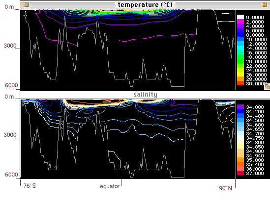 shows the temperature and salinity distribution in a meridional section through the Pacific Ocean as an example. Notice the
uniformity of both properties below 1,000 m depth. Notice also that in many ocean regions, temperature and salinity both
decrease with depth. A decrease in temperature results in an increase of density, so the temperature stratification produces
a stable density stratification. A decrease in salinity, on the other hand, produces a density decrease. Taken on its own,
the salinity stratification would therefore produce an unstable density stratification. In the ocean the effect of the
temperature decrease is stronger than the effect of the salinity decrease, so the ocean is stably stratified. In contrast
to the subsurface temperature distribution, the subsurface salinity distribution shows intermediate minima. They are linked
with water mass formation at the Polar Fronts where precipitation is high; details will be discussed later in the course.
At very great depth, salinity increases again because the water near the ocean bottom originates from polar regions where
it sinks during the winter; freezing during the process increases its salinity.
shows the temperature and salinity distribution in a meridional section through the Pacific Ocean as an example. Notice the
uniformity of both properties below 1,000 m depth. Notice also that in many ocean regions, temperature and salinity both
decrease with depth. A decrease in temperature results in an increase of density, so the temperature stratification produces
a stable density stratification. A decrease in salinity, on the other hand, produces a density decrease. Taken on its own,
the salinity stratification would therefore produce an unstable density stratification. In the ocean the effect of the
temperature decrease is stronger than the effect of the salinity decrease, so the ocean is stably stratified. In contrast
to the subsurface temperature distribution, the subsurface salinity distribution shows intermediate minima. They are linked
with water mass formation at the Polar Fronts where precipitation is high; details will be discussed later in the course.
At very great depth, salinity increases again because the water near the ocean bottom originates from polar regions where
it sinks during the winter; freezing during the process increases its salinity.
 shows examples of sound speed profiles. Note the curves for the Weddell Sea and the Mediterranean Sea: The Weddell Sea does
not have a thermal stratification, hence no temperature effect on c. The Mediterranean Sea demonstrates the effect of salinity
on c. The profile is similar to those of other tropical ocean regions, but the higher salinity of the Mediterranean Sea
increases c at all levels.
shows examples of sound speed profiles. Note the curves for the Weddell Sea and the Mediterranean Sea: The Weddell Sea does
not have a thermal stratification, hence no temperature effect on c. The Mediterranean Sea demonstrates the effect of salinity
on c. The profile is similar to those of other tropical ocean regions, but the higher salinity of the Mediterranean Sea
increases c at all levels.
 gives examples of horizontal sound paths. The first diagram shows sound propagation at the depth of the sound speed minimum
(usually about 1,000 m). Sound rays bend back towards the depth of minimum sound speed and travel at that depth over large
distances (they can traverse entire oceans). This sound channel is known as the SOFAR (SOund Fixing And Ranging) channel.
Before the introduction of the Global Positioning System (GPS) the SOFAR channel was used to locate ships and aircraft in
distress, and for tracking floats (with two or more receivers) for the study of ocean currents. The second diagram shows a
situation where a mixed layer of uniform temperature (typically about 100 m thick) is found on top of the normal temperature
stratification. In this case sound speed increases below the surface due to the increase in pressure before the normal decrease
due to temperature takes over. The resulting sound speed maximum at about 100 m depth creates a shadow zone, since all sound
rays bend away from that depth.
gives examples of horizontal sound paths. The first diagram shows sound propagation at the depth of the sound speed minimum
(usually about 1,000 m). Sound rays bend back towards the depth of minimum sound speed and travel at that depth over large
distances (they can traverse entire oceans). This sound channel is known as the SOFAR (SOund Fixing And Ranging) channel.
Before the introduction of the Global Positioning System (GPS) the SOFAR channel was used to locate ships and aircraft in
distress, and for tracking floats (with two or more receivers) for the study of ocean currents. The second diagram shows a
situation where a mixed layer of uniform temperature (typically about 100 m thick) is found on top of the normal temperature
stratification. In this case sound speed increases below the surface due to the increase in pressure before the normal decrease
due to temperature takes over. The resulting sound speed maximum at about 100 m depth creates a shadow zone, since all sound
rays bend away from that depth.
 ), while oxygen concentration (
 ) decreases. Departures from this rule are caused by advection of different water. Oxygen and nutrients are linked in a
cycle of uptake and release, so a fixed ration of their concentrations is found in open ocean water. AOU : C : N : P =
212 : 106 : 16 : 1 on atomic weight = 109 : 41 : 7.2 : 1 in grams. Where ; AOU (apparent oxygen utilisation) = saturation
concentration - observed concentration, C = carbon, N = nitrogen, P = phosphorus.
) decreases. Departures from this rule are caused by advection of different water. Oxygen and nutrients are linked in a
cycle of uptake and release, so a fixed ration of their concentrations is found in open ocean water. AOU : C : N : P =
212 : 106 : 16 : 1 on atomic weight = 109 : 41 : 7.2 : 1 in grams. Where ; AOU (apparent oxygen utilisation) = saturation
concentration - observed concentration, C = carbon, N = nitrogen, P = phosphorus.
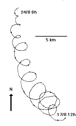 gives an example from the Baltic Sea.
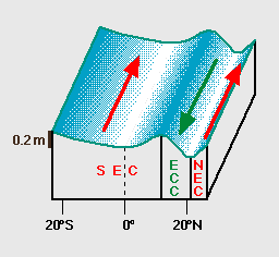 shows an example of geostrophic flow in the equatorial current system. Note that the variations in sea level are only of
the order 0.2 - 0.4 m. These small variations are impossible to verify in the open ocean. They have, however, been varified
in narrow straits, where a reversal of the current flowing through the strait produces a reversal of the sea surface tilt
across the strait. The tilt can be measured with sea level gauges on both sides. Another important aspect of geostrophic
flow relates to the circulation around eddies.
shows an example of geostrophic flow in the equatorial current system. Note that the variations in sea level are only of
the order 0.2 - 0.4 m. These small variations are impossible to verify in the open ocean. They have, however, been varified
in narrow straits, where a reversal of the current flowing through the strait produces a reversal of the sea surface tilt
across the strait. The tilt can be measured with sea level gauges on both sides. Another important aspect of geostrophic
flow relates to the circulation around eddies.
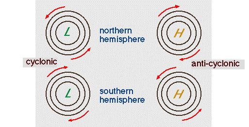 shows the principle. It applies equally to oceanic and atmospheric eddies and explains why a high pressure system to the
east of Adelaide in South Australia brings northerly winds.
shows the principle. It applies equally to oceanic and atmospheric eddies and explains why a high pressure system to the
east of Adelaide in South Australia brings northerly winds.
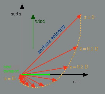 ); but an important result of the balance of forces is that the net (ie vertically averaged) transport in the Ekman layer
is directed perpendicular to the wind direction, to the left in the southern hemisphere and to the right in the northern
hemisphere.
); but an important result of the balance of forces is that the net (ie vertically averaged) transport in the Ekman layer
is directed perpendicular to the wind direction, to the left in the southern hemisphere and to the right in the northern
hemisphere.
 ).
).