Stormwater Management...
Adoption of Best Management Practices...
The City of Naperville has adopted the Best Management Practices (BMP) approach for the design of all stormwater and
floodplain management system components. The basis of this approach is the City’s support of “The Upper DuPage River
Watershed Implementation Plan” developed by The Conservation Foundation and The DuPage River Coalition in 1998. Except
as modified and/or appended herein, all stormwater management components covered in this section shall be designed as
Best Management Practices (BMP’s) in accordance with the most current edition of “Urban Stormwater Best Management
Practices for Northeastern Illinois” published by the Northeastern Illinois Planning Commission.
Hydrologic Analysis...
General...
The City of Naperville uses the term “Design Storm” to define precipitation events used in the design and analysis of
all stormwater management facilities in the City. The Design Storm is the frequency with which a given rainfall event
is equaled or exceeded, on average, once in a period of years. The probability of occurrence is equal to the reciprocal
of the design storm frequency. For example, a 100-year design storm has a 1.0 percent probability of occurrence in any
one year.
Rainfall Data...
The Illinois State Water Survey (ISWS) publication entitled “Frequency Distributions and Hydroclimatic Characteristics of
Heavy Rainstorms in Illinois,” commonly called “Bulletin 70” shall be used as the rainfall data reference source for the
design of stormwater management facilities.
Design Storm...
The standard design storm for all Minor Drainage System components will be the appropriate “10-year recurrence interval”
rainfall, as defined in ISWS Bulletin 70. The standard design storm for all Major Drainage System components will be the
appropriate “100-year recurrence interval” rainfall, as defined in ISWS Bulletin 70.
Topographic Data...
Topographic data shall be referenced to at least one established City of Naperville benchmark. Contour intervals shall be
one foot and shall directly correlate to the City datum.
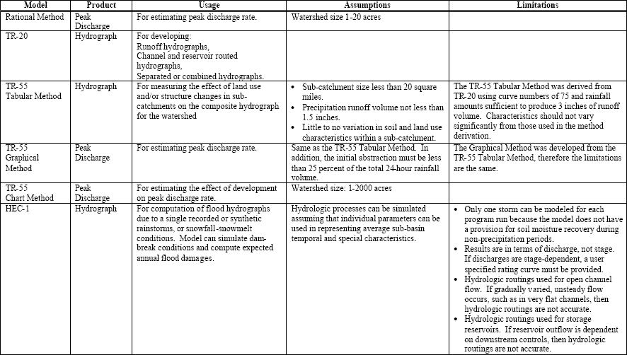
Rainfall-Runoff Modeling Methodology...
The following summarizes the application of common rainfall-runoff models.
 Hydraulic Analysis...
General...
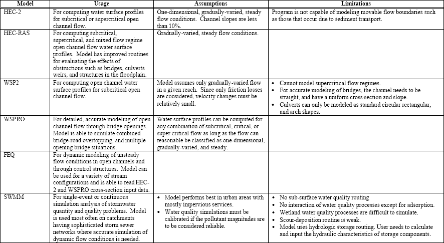
The following table summarizes the application of common hydraulic models.
Hydraulic Analysis...
General...
The following table summarizes the application of common hydraulic models.
 Gravity Flow...
All stormwater management facilities in the City of Naperville shall be designed for gravity- flow conditions for the
appropriate design storm. Stormwater pumping facilities will only be considered if it can be demonstrated that there is
no means of providing for gravity-flow drainage. The design of each stormwater management component must be based on
sub-critical flow conditions. Super-critical or critical flow conditions have the potential for high velocities that are
dangerous and damaging. Furthermore, these conditions are unstable and can result in widely fluctuating and unpredictable
flow depths.
Pressure Flow...
Pressure flow conditions occur in a closed-conduit system when the hydraulic grade line (HGL) is above the crown of the
pipe. When it is not possible to restrict the HGL to the crown of the pipe, due to topographic constraints, the HGL may
be contained within the rim, as approved by the City Engineer. Storm sewers shall be designed for the appropriate design
storm based on flowing- full conditions without any pressure head. While pressure flow conditions may occur for runoff
events in excess of the design storm, such conditions should be avoided by allowing excess flows to be channeled to
overflow routes.
Minor Drainage System...
Gravity Flow...
All stormwater management facilities in the City of Naperville shall be designed for gravity- flow conditions for the
appropriate design storm. Stormwater pumping facilities will only be considered if it can be demonstrated that there is
no means of providing for gravity-flow drainage. The design of each stormwater management component must be based on
sub-critical flow conditions. Super-critical or critical flow conditions have the potential for high velocities that are
dangerous and damaging. Furthermore, these conditions are unstable and can result in widely fluctuating and unpredictable
flow depths.
Pressure Flow...
Pressure flow conditions occur in a closed-conduit system when the hydraulic grade line (HGL) is above the crown of the
pipe. When it is not possible to restrict the HGL to the crown of the pipe, due to topographic constraints, the HGL may
be contained within the rim, as approved by the City Engineer. Storm sewers shall be designed for the appropriate design
storm based on flowing- full conditions without any pressure head. While pressure flow conditions may occur for runoff
events in excess of the design storm, such conditions should be avoided by allowing excess flows to be channeled to
overflow routes.
Minor Drainage System...
General...
The minor drainage system consists of curb and gutter sections, storm sewers (with appurtenant inlets, catch basins, and
manholes), swales (side yard, back yard), and small natural or man-made open channels. The function of the minor drainage
system is to quickly collect and convey the runoff from the smaller, more frequent storms. Except as modified and/or
appended herein, all minor drainage system components covered in this section shall be designed in accordance with the
most current edition of the Illinois Department of Transportation (IDOT) Drainage Manual.
Swales...
Side yard and rear yard swales shall be analyzed as open channels with a triangular crosssection and a mowed turf grass
surface. The minimum longitudinal slope should be 2 percent. Where hardship is demonstrated, 1.5 percent may be permitted.
The maximum slope allowed is 25 percent. The swale shall have sufficient hydraulic capacity to convey the design storm
peak flow rate with the appropriate freeboard clearances. For residential developments, there shall be not less than 1.5
feet of freeboard between the design high water level in the swale and the lowest adjacent top of foundation elevation.
For commercial developments, there shall be no less than 1.0 feet of freeboard between the design high water level in the
swale and the lowest adjacent top of foundation elevation.
Pavement Drainage...
Maximum flow depths on any roadway shall not exceed 6 inches during the base flood condition. Inlets are to be located such
that these encroachments are not exceeded and that flow will not cross-intersecting streets. These standards will apply to
all local and collector streets. The following table provides equations that should be used in computing inlet spacing.
The equations are based on the standard City of Naperville gutter width of 12 inches, and a recommended pavement roughness
coefficient of 0.015. The maximum flow depth at the face of curb is about 1.7 inches which occurs for the steepest
cross-slope of 2.5%. These equations ; therefore, are applicable for both roll and barrier curb situations.
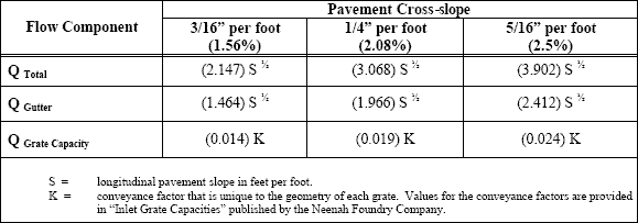
For the ponded water condition, stormwater flow bypassed from uphill inlets accumulates at a low point. At lower depths,
the flow into most inlet grates takes on the characteristics of flow though a weir. As the ponding depth increases, the
inlet grate opening acts more like an orifice. The equations and assumptions applicable for both types of ponded condition
flow are found in the above referenced Neenah Foundry publication.
Storm Sewers...
Storm sewers shall be designed in accordance with the procedures outlined in Chapter 8 of the IDOT Drainage Manual. These
procedures use the Rational Method to determine peak stormwater flow rates for both inlet spacing and storm sewer sizing.
All storm sewers that will be within the City of Naperville right-of-way shall be designed with the appropriate ASTM Class
of reinforced concrete pipe (RCP). Every effort shall be made to minimize the placement of storm sewers in side yard easements. All storm sewer pipes within side yard easements shall have gasketed joints. For RCP, these joints shall be
in accordance with ASTM specification C-361. Storm sewers sizes are to be determined based on flowing- full
(non-surcharging) conditions for the appropriate design storm. The minimum and maximum allowable subcritical design
flow velocities are 2.5 fps and 10 fps, respectively. A conventional development has one or more storm sewer networks that
discharge to the detention facility for the site. To avoid surcharging conditions, storm sewer outfalls to detention
facilities shall be designed such that the invert of the outfall pipe is at or higher than the normal high water elevation
of the facility. An exception to this policy will be made if the hydraulic grade line calculations can demonstrate that
the design water surface is kept below the street edge of pavement elevation throughout the site.
Culverts...
All culverts that will be within the City of Naperville right-of-way shall be designed with the appropriate ASTM Class of
RCP and will have the appropriately sized precast concrete flared-end section on each end. All culverts over 12 inches in
diameter shall have the appropriate grating covering the flared-end section opening.
Major Drainage System...
General...
The major drainage system consists of overflow routes (streets and larger natural or man-made open channels), man-made
stormwater storage facilities (basins and ponds), large natural or manmade channels, and floodplains. The major drainage
system serves both conveyance and storage functions. This may occur as a result of runoff from the larger, less frequent
storms and/or from an obstruction in the minor system.
Overflow Routes...
General...
Overflow routes should exit a developed site in a common area that is preferably public property such as a park or public
right-of-way. As a secondary choice, overflow routes can be designated along a common rear yard property line that is
furthest away from homes and buildings.
Swales...
Overflow route swales shall be analyzed as open channels with a triangular cross-section and a mowed turf grass surface.
An overflow route swale shall have side-slopes that are a minimum of 2 percent and maximum of 25 percent. The longitudinal
slope should be 2 percent. Where hardship is demonstrated, 1.5 percent may be permitted. The maximum slope allowed is 25
percent. The overflow route swale will have sufficient hydraulic capacity to convey the design storm peak flow rate with
the appropriate freeboard clearances. For residential developments, there shall be no less than 1.5 feet of freeboard
between the design highwater level in the swale and the lowest adjacent top of foundation elevation. For commercial
developments, there shall be no less than 1.0 feet of freeboard between the design highwater level in the swale and the
lowest adjacent top of foundation elevation.
Stormwater Storage...
Floodplain Compensatory Storage...
Existing floodplain storage will be preserved and maintained for the post-development condition. For streams with mapped
FEMA Zone AE floodplain (base floodplain elevations determined and subsequently approved by FEMA), the floodplain will
consist of the base flood elevation(s) set onto the approved site topography. For streams with mapped FEMA Zone A
floodplain (no base floodplain elevations determined), the floodplain will need to be determined with hydrologic and
hydraulic modeling acceptable to the IDNR and the City of Naperville.
Natural Depressional Storage...
Isolated depressional areas can provide a significant amount of natural stormwater storage in a watershed. Therefore, they
shall be included in determining the natural release rate to be compared to the allowable release rate.
Stormwater Detention...
General...
Detention requirements within the City of Naperville are subject to review under both the City’s storm runoff control
ordinance in addition to applicable county ordinances. Upon review, the more conservative application will apply. The
City of Naperville’s storm runoff control ordinance states that detention is required for all commercial developments.
Detention will also be required for residential developments of 2.5 acres or greater. For residential developments less
than 2.5 acres in area, BMP’s that facilitate stormwater infiltration will be required. The stormwater release rate is
the lesser value of: the applicable County release rate or the natural release rate.
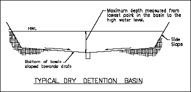
Basins...
A detention basin is a facility that normally drains completely between runoff events. The maximum side-slopes of a
detention basin adjacent to a residential area, including multifamily developments, shall be 6 to 1 (6:1, or 6 feet
horizontally for every 1 foot drop in elevation). The maximum side-slopes of a detention basin adjacent to a commercial
area shall be 4 to 1. The maximum depth of stormwater storage in a detention basin shall be 6 feet. This depth is measured
from the lowest point in the basin (located at the invert of the outlet pipe or at the rim elevation of an inlet grate) to
the design high water elevation as illustrated below. The bottom of a detention basin must be sloped toward the outlet or
inlet grate(s) to provide drainage after it has stored stormwater. The bottom slope will be a recommended 2 percent with
an allowable range of 1.5 percent minimum and 25 percent maximum.
Ponds...
A detention pond is a facility that maintains a fixed minimum water elevation between runoff events. This definition
excludes the water volume losses due to infiltration, evaporation, or de-watering due to periodic maintenance. The maximum
side-slopes of a detention pond adjacent to a residential area, including multi- family developments, shall be 6 to 1
(6:1, or 6 feet horizontally for every 1 foot drop in elevation). The maximum sideslopes of a detention pond adjacent to a
commercial area shall be 4 to 1. The maximum depth of stormwater storage in a detention pond shall be 6 feet. This depth is
measured from the normal water level elevation to the design high water elevation.
Aeration Facilities...
Aeration facilities to prevent pond stagnation shall be provided. Design calculations to substantiate the effectiveness
of these aeration facilities shall be submitted with final engineering plans. Agreements for the perpetual operation and
maintenance of aeration facilities shall be prepared to the satisfaction of the municipality. When detention ponds have
been designed to promote the growth of a riparian environment, the use of aeration devices may be waived with approval
from the City Engineer.
At least one quarter of the detention pond area (as measured at the normal water level) shall have a minimum depth of 10
feet below the normal water level to provide a refuge for fish to survive during the winter.
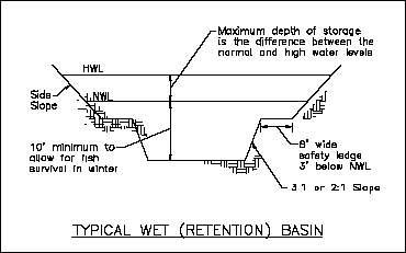
A detention pond must have an 8 foot wide safety ledge located 3 feet below the normal water level where emergent plants
are not desired, unless a justification is otherwis e provided and approved by the City Engineer. This safety ledge
provides a stopping point for someone who may have inadvertently fallen into the water.
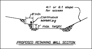
Retaining Walls Used for Detention Facilities...
Retaining walls are not permitted in or adjacent to single- family residential developments. Where permitted, retaining
walls around stormwater detention facilities shall not exceed three feet in height. If a wall greater than 3 feet in
height is required, the wall must be terraced after the first 3- foot high lift. A minimum horizontal space of 8 feet
will be required between wall lifts. A landscape buffer will be required around the back of the bottom retaining wall as
illustrated below.
 Parking Lot Detention...
A maximum depth of 1 foot will be allowed for stormwater storage on parking lots.
Underground Detention...
Underground storage is allowed if there is no practical alternative to construct a surface detention facility. The City
will require that the owner of an underground detention facility have a qualified engineer inspect the system annually
and subsequently furnish an inspection report to the City Engineer. The report will include a certification that the
condition of the detention system is such that it will operate in accordance with the original design intent. The Plat of
Dedication and/or Plat of Easement for the development will include specific language to cover this requirement.
Fee-in-Lieu-of Detention...
A fee may be paid in lieu of a detention basin or pond if it can be demonstrated that site conditions are such that there
is no practical means of constructing such a facility and that there will be no adverse impacts to areas downstream of the
site if a detention facility is not provided. The Naperville City Council must approve this alternative before it can be
implemented. The fee is computed as $94,000 multiplied by the acre-feet of storage that would be required for the proposed
site development. This fee may be adjusted with time; therefore, the current fee amount should be confirmed with the City
Engineer.
Location of Detention Facilities...
The minimum separation between the right-of-way of a public street and the high water level of a detention basin or pond
is 10 feet plus one and one half times the maximum design depth of the detention facility.
Use of Public Streets for Detention Prohibited...
Public street pavements shall not be used for stormwater detention storage.
Floodplain Management...
Development Standards...
For streams with mapped FEMA Zone AE floodplain (base floodplain elevations determined and subsequently approved by FEMA),
the floodplain will consist of the base flood elevation(s) set onto the approved site topography. For streams with mapped
FEMA Zone A floodplain (no base floodplain elevations determined), the floodplain will need to be determined with hydrologic
and hydraulic modeling acceptable to the IDNR and the City of Naperville with the resulting floodplain delineation based on
the approved site topography.
LOMR Requirements...
For streams with mapped FEMA Zone A floodplain, there will be, in most cases, a discrepancy between the FEMA delineated
Zone A floodplain and the newer, refined delineation. Both delineations need to be shown on the final engineering master
grading plan. New development will be allowed in FEMA delineated Zone A floodplain areas that are not part of the approved
refined delineation. The developer will be required to apply for and receive a FEMA Letter of Map Revision (LOMR) before
the City will issue building permits for the habitable structures proposed for these areas. The City of Naperville will
require that the builder submit a FEMA Elevation Certificate for these structures at the time that the Final Grading Survey
(FGS) is submitted.
Parking Lot Detention...
A maximum depth of 1 foot will be allowed for stormwater storage on parking lots.
Underground Detention...
Underground storage is allowed if there is no practical alternative to construct a surface detention facility. The City
will require that the owner of an underground detention facility have a qualified engineer inspect the system annually
and subsequently furnish an inspection report to the City Engineer. The report will include a certification that the
condition of the detention system is such that it will operate in accordance with the original design intent. The Plat of
Dedication and/or Plat of Easement for the development will include specific language to cover this requirement.
Fee-in-Lieu-of Detention...
A fee may be paid in lieu of a detention basin or pond if it can be demonstrated that site conditions are such that there
is no practical means of constructing such a facility and that there will be no adverse impacts to areas downstream of the
site if a detention facility is not provided. The Naperville City Council must approve this alternative before it can be
implemented. The fee is computed as $94,000 multiplied by the acre-feet of storage that would be required for the proposed
site development. This fee may be adjusted with time; therefore, the current fee amount should be confirmed with the City
Engineer.
Location of Detention Facilities...
The minimum separation between the right-of-way of a public street and the high water level of a detention basin or pond
is 10 feet plus one and one half times the maximum design depth of the detention facility.
Use of Public Streets for Detention Prohibited...
Public street pavements shall not be used for stormwater detention storage.
Floodplain Management...
Development Standards...
For streams with mapped FEMA Zone AE floodplain (base floodplain elevations determined and subsequently approved by FEMA),
the floodplain will consist of the base flood elevation(s) set onto the approved site topography. For streams with mapped
FEMA Zone A floodplain (no base floodplain elevations determined), the floodplain will need to be determined with hydrologic
and hydraulic modeling acceptable to the IDNR and the City of Naperville with the resulting floodplain delineation based on
the approved site topography.
LOMR Requirements...
For streams with mapped FEMA Zone A floodplain, there will be, in most cases, a discrepancy between the FEMA delineated
Zone A floodplain and the newer, refined delineation. Both delineations need to be shown on the final engineering master
grading plan. New development will be allowed in FEMA delineated Zone A floodplain areas that are not part of the approved
refined delineation. The developer will be required to apply for and receive a FEMA Letter of Map Revision (LOMR) before
the City will issue building permits for the habitable structures proposed for these areas. The City of Naperville will
require that the builder submit a FEMA Elevation Certificate for these structures at the time that the Final Grading Survey
(FGS) is submitted.