
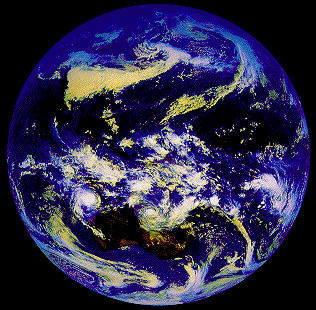
 and
and
 show examples of eddies in the atmosphere and in the ocean. Note the difference in scale: Atmospheric eddies are typically
some 2,000 km in diameter, while oceanic eddy diameter are typically 200 km. A movie sequence of images taken from the
weather satellite or from the ocean model would show that atmospheric time scales are also different: At any given location,
atmospheric eddies pass at a rate of one eddy every 5 - 7 days (experienced as the passage of fronts), while oceanic eddy
movement is such that the passage of an eddy takes 50 - 70 days. The aim of oceanography is an understanding of the oceanic
circulation and the distribution of heat in the ocean, how the ocean interacts with the atmosphere, and what role the ocean
plays in maintaining our climate.
show examples of eddies in the atmosphere and in the ocean. Note the difference in scale: Atmospheric eddies are typically
some 2,000 km in diameter, while oceanic eddy diameter are typically 200 km. A movie sequence of images taken from the
weather satellite or from the ocean model would show that atmospheric time scales are also different: At any given location,
atmospheric eddies pass at a rate of one eddy every 5 - 7 days (experienced as the passage of fronts), while oceanic eddy
movement is such that the passage of an eddy takes 50 - 70 days. The aim of oceanography is an understanding of the oceanic
circulation and the distribution of heat in the ocean, how the ocean interacts with the atmosphere, and what role the ocean
plays in maintaining our climate.
 the use of a curved longitude grid
 and therefore require a grid drawn over the map surface to enable determination of geographical location coordinates
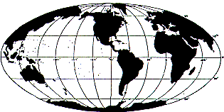 .
The Gall/Peters projection, which was developed by Gall in
1855 and rediscovered again independently by Peters in the 1970s, combines fidelity of area with a rectangular latitude/longitude
grid. It is ideal for mapping large ocean regions.
.
The Gall/Peters projection, which was developed by Gall in
1855 and rediscovered again independently by Peters in the 1970s, combines fidelity of area with a rectangular latitude/longitude
grid. It is ideal for mapping large ocean regions.
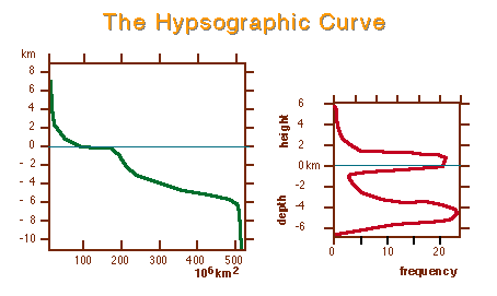 .
Average elevation - 2,440 m; mean land elevation + 840 m, average ocean floor level - 3,795 m. The major oceans are
structured into continental margins, mid- ocean ridges and deep sea basins
.
Average elevation - 2,440 m; mean land elevation + 840 m, average ocean floor level - 3,795 m. The major oceans are
structured into continental margins, mid- ocean ridges and deep sea basins
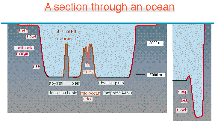 .
Each structural feature occupies about one third of the ocean floor.
.
Each structural feature occupies about one third of the ocean floor.
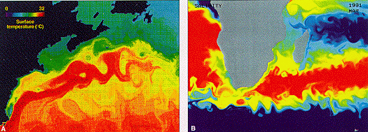
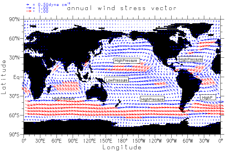 shows that in the open ocean winds are nearly zonal (blowing east-west). The Trade Winds are easterly winds in the tropics
and subtropics (between 30°N and 30°S). They are regions of extremely uniform wind conditions, where the wind blows steadily
from the same direction with moderate strength throughout the year. Their strength increases slightly in winter. The Trade
Winds of the two hemispheres are separated by the Doldrums, a region of weak and variable winds near 5°N. Between 30° and
65° are the Westerlies. They are stronger in winter than in summer and are regions of frequent storms. Poleward of 65° the
wind direction reverses again, and the Polar Easterlies blow from east to west.
shows that in the open ocean winds are nearly zonal (blowing east-west). The Trade Winds are easterly winds in the tropics
and subtropics (between 30°N and 30°S). They are regions of extremely uniform wind conditions, where the wind blows steadily
from the same direction with moderate strength throughout the year. Their strength increases slightly in winter. The Trade
Winds of the two hemispheres are separated by the Doldrums, a region of weak and variable winds near 5°N. Between 30° and
65° are the Westerlies. They are stronger in winter than in summer and are regions of frequent storms. Poleward of 65° the
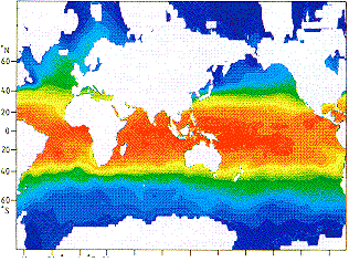
wind direction reverses again, and the Polar Easterlies blow from east to west.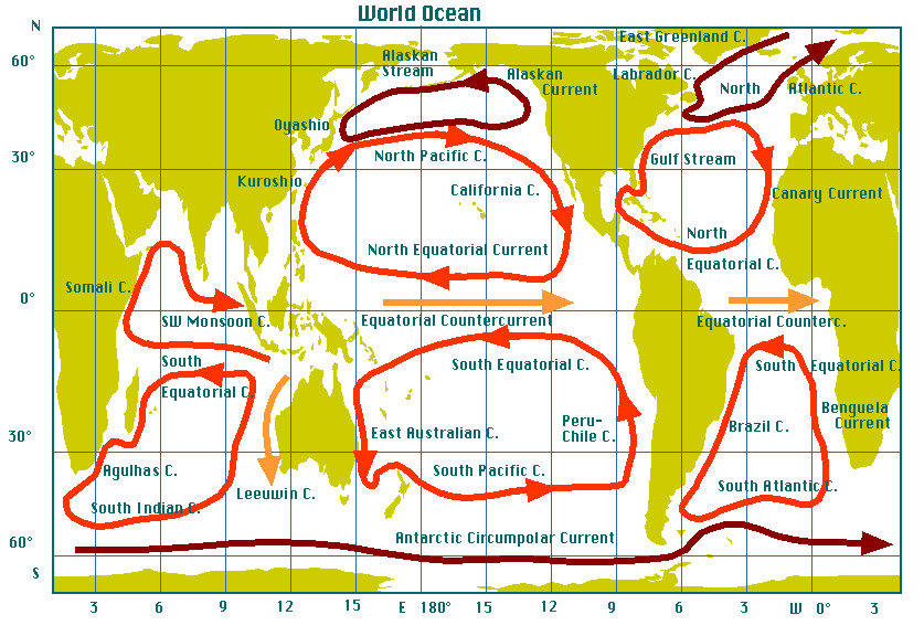 is a map of surface currents. The combined action of the Trade Winds and the Westerlies produces large gyres, with clockwise
rotation in the northern hemisphere, anti-clockwise rotation in the southern hemisphere, known as the subtropical gyres. A
subpolar gyre is produced in the north Pacific Ocean by the combined action of the Westerlies and the Polar Easterlies; it
consists of the Oyashio, North Pacific Current and Alaskan Current. An indication of a subpolar gyre is also seen in the
north Atlantic Ocean (anti-clockwise rotation in the current system that includes the North Atlantic, East Greenland and
Labrador Currents). The subpolar region of the southern hemisphere does not have land barriers and therefore is dominated
by the Antarctic Circumpolar Current.
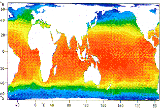
shows the situation during the Southwest Monsoon season when the Equatorial Countercurrent is suppressed and the circulation
in the northern Indian Ocean differs significantly from that of the other ocean basins. Just as in the atmosphere, where wind
systems are linked to atmospheric pressure patterns, ocean currents are linked to pressure patterns in the ocean. Pressure at
any depth in the ocean is determined by the weight of the water above, which is determined by the density of the water, which
in turn depends on the water's temperature and salinity. It follows that ocean currents can be determined by measuring
temperature and salinity, a task infinitely easier than direct current measurement. It is therefore appropriate to turn
to a discussion of the basic properties of seawater before proceeding with a discussion of the oceanic circulation and the
physical laws that govern it.
is a map of surface currents. The combined action of the Trade Winds and the Westerlies produces large gyres, with clockwise
rotation in the northern hemisphere, anti-clockwise rotation in the southern hemisphere, known as the subtropical gyres. A
subpolar gyre is produced in the north Pacific Ocean by the combined action of the Westerlies and the Polar Easterlies; it
consists of the Oyashio, North Pacific Current and Alaskan Current. An indication of a subpolar gyre is also seen in the
north Atlantic Ocean (anti-clockwise rotation in the current system that includes the North Atlantic, East Greenland and
Labrador Currents). The subpolar region of the southern hemisphere does not have land barriers and therefore is dominated
by the Antarctic Circumpolar Current.
shows the situation during the Southwest Monsoon season when the Equatorial Countercurrent is suppressed and the circulation
in the northern Indian Ocean differs significantly from that of the other ocean basins. Just as in the atmosphere, where wind
systems are linked to atmospheric pressure patterns, ocean currents are linked to pressure patterns in the ocean. Pressure at
any depth in the ocean is determined by the weight of the water above, which is determined by the density of the water, which
in turn depends on the water's temperature and salinity. It follows that ocean currents can be determined by measuring
temperature and salinity, a task infinitely easier than direct current measurement. It is therefore appropriate to turn
to a discussion of the basic properties of seawater before proceeding with a discussion of the oceanic circulation and the
physical laws that govern it.
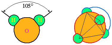 ;
the charges would be neutralized if the angle were 180° rather than 105°.
;
the charges would be neutralized if the angle were 180° rather than 105°.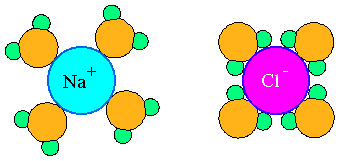 ). As a consequence, dissolved material greatly increases the electrical conductivity of water. The conductivity of pure
water is relatively low, but that of sea water is midway between pure water and copper. At 20°C, the resistance of sea water
of 3.5% salt content over 1.3 km roughly equals that of pure water over 1 mm. (3) The angle 105° is close to the angle of a
tetrahedron, i.e. a structure with four arms emanating from a centre at equal angles (109° 28´). As a result, oxygen atoms
in water try to have four hydrogen atoms attached to them in a tetrahedral arrangement (
). This is called a "hydrogen bond", in contrast to the (ionic) molecular bond and covalent bonding. Hydrogen bonds need a
bonding energy 10 to 100 times smaller than molecular bonds, so water is very flexible in its reaction to changing chemical
conditions. (4) Tetrahedrons are of a more wide-meshed nature than the molecular closest packing arrangement. They form
aggregates of single, two, four and eight molecules. At high temperatures the one and two molecule aggregates dominate; as
the temperature falls the larger clusters begin to dominate (
). As a consequence, dissolved material greatly increases the electrical conductivity of water. The conductivity of pure
water is relatively low, but that of sea water is midway between pure water and copper. At 20°C, the resistance of sea water
of 3.5% salt content over 1.3 km roughly equals that of pure water over 1 mm. (3) The angle 105° is close to the angle of a
tetrahedron, i.e. a structure with four arms emanating from a centre at equal angles (109° 28´). As a result, oxygen atoms
in water try to have four hydrogen atoms attached to them in a tetrahedral arrangement (
). This is called a "hydrogen bond", in contrast to the (ionic) molecular bond and covalent bonding. Hydrogen bonds need a
bonding energy 10 to 100 times smaller than molecular bonds, so water is very flexible in its reaction to changing chemical
conditions. (4) Tetrahedrons are of a more wide-meshed nature than the molecular closest packing arrangement. They form
aggregates of single, two, four and eight molecules. At high temperatures the one and two molecule aggregates dominate; as
the temperature falls the larger clusters begin to dominate (
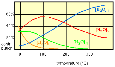 ). The larger clusters occupy more space than the same number of molecules in smalles clusters. As a result, the density of
water shows a maximum at 4°C.
). The larger clusters occupy more space than the same number of molecules in smalles clusters. As a result, the density of
water shows a maximum at 4°C.| A list of some minimum temperatures (the physical property is given first, followed by the temperature in °C at which the minimum occurs) | |
| Oxygen solubility | 80 |
| Specific volume | 4 |
| Specific heat | 34 |
| Hydrogen solubility | 37 |
| Compressibility | 44 |
| Speed of light | - 1 |
| Speed of sound (max) | 74 |
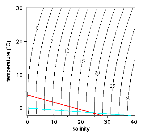 ). Oceanic density is usually close to 1,025 kg / m3 (In freshwater it is close to 1,000 kg / m3).
Oceanographers usually use the symbol st (the Greek letter sigma with a subscript t) for density, which they pronounce
"sigma-t". This quantity is defined as st = r - 1000 and does not usually carry units (it should carry the same units as
r). A typical seawater density is thus st = 25 (
). Oceanic density is usually close to 1,025 kg / m3 (In freshwater it is close to 1,000 kg / m3).
Oceanographers usually use the symbol st (the Greek letter sigma with a subscript t) for density, which they pronounce
"sigma-t". This quantity is defined as st = r - 1000 and does not usually carry units (it should carry the same units as
r). A typical seawater density is thus st = 25 (
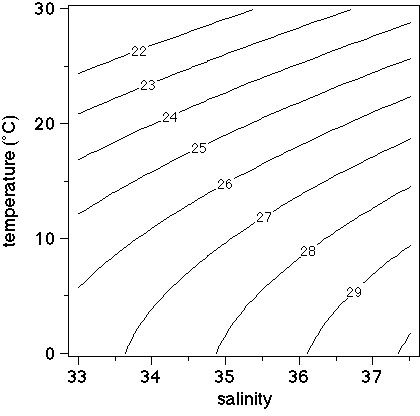 ). A useful rule of thumb is that st changes by the same amount if T changes by 1°C, S by 0.1, and p by the equivalent of
a 50 m depth change.
). A useful rule of thumb is that st changes by the same amount if T changes by 1°C, S by 0.1, and p by the equivalent of
a 50 m depth change.