| Tunceli... |
|
A province surrounded by mountains exhibiting a majestic view, Tunceli is a land with untouched natural beauties; and an
area of rocky steep cliffs displaying a wild appearance; this province with its peculiar characteristics lies 133 km north
of Elazig. Known as "Dersim" in the old times, Tunceli has followed a similar historical evolution as other
cities of Eastern Anatolia. Beginning with the Urartians, it changed hands among Persians, Romans, Byzantines and Ottomans,
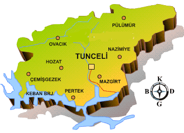
and today it is a modern province with remains from these periods. One important ruin is the fortress of Pertek, outside
the city, on the road to Elazig. It was constructed in the Middle Ages, and is a place to be explored by sightseers.
Mazgirt fortress and several old bridges are other historical places around Tunceli. Nearby, there exists another beautiful
spot, the Munzur Valley National Park with its wide natural resources. It is possible to make use of the curative properties
of its mineral springs, while the streams are filled with trout, providing opportunities for fishing. This site is also an
ideal destination for mountaineers and the whole park possesses a wonderful scenery that will amaze nature lovers. High
mountains encircle Tunceli, 133 km north of Elazig on the Elazig-Erzurum road. On the way, stop off to see the fortress
of Pertek, built in the Middle Ages and still in good condition today. In the Munzur Valley National Park near Ovacik, 60
km northwest of Tunceli, you can fish in rushing, trout-filled streams while enjoying the amazing scenery. The Keban and
Karakaya dams on the Firat river have created huge artificial lakes, dramatically altering the surrounding environment.
Twenty-five kilometers south of Elazig, the lovely and tranquil Hazar lake invites relaxation. High mountains encircle
Tunceli, 133 km north of Elazig on the Elazig-Erzurum road, On the way stop off to see the fortress of Pertek, built in
the Middle Ages and still in good condition today. In the Menzur Valley National Park near Ovacik, 60 km northwest of
Tunceli, you can fish in rushing trout-filled streams while enjoying the amazing scenery. Türkiye is, and has been for
a long time, located in the Palearctic zone. For this reason, its current bio-geographic composition and structure may
be seen as representative of Palearctic flora and fauna. However, especially in the Southeast and the East, the Influence
of oriental and Ethiopic (African) elements are observable although this influence diminishes as one goes north.
|
|
|
 428...
 62...
62...
 93,584...
 7,774...
 39 E 32 - 39 N 07...