|
|
|||||||||||||||||||||
|
|
|||||||||||||||||||||
|
Paphlagonian Hadrianoupolis

Geographical Location A Bilance of Past Researches History Phyrgians Hellenistic Period Kingdom of Paphlagonia Romans Early Byzantine Paphlagonia Byzantine First Turkish Settlers Field Surveys at Hadrianoupolis 2005 2006 Field Surveys at Kimistene 2005 2006 Excavations at Hadrianoupolis 2003 2006 2007 Excavations at Kimistene 2006 2007 Archaeometry “Phyrgian” Pottery Mortar Analysis Geophysical Research 2006 Church B Church C Tumulus Team List 2003 2005 2006 2007 Paphlagonia Geographical Location Natural Sources Forestry Maritime Economy A Bilance of Past Researches History Before the IIIrd Millenium B.C. IIIrd Millenium B.C. IInd Millenium B.C. Hittites Ist Millenium B.C. Phyrgians Greek Colonies Achaemenids Hellenistic Period Kingdom of Paphlagonia Romans Early Byzantine Paphlagonia Middle Byzantine Period First Turkish Settlers Major Paphlagonian Cities Sinope Heracleia Pontica Amastris Abonouteichus Gangra Germanicoupolis Neoclaudioupolis Pompeioupolis Sebaste Sesamus Cromna Pimolisa Safranbolu Hacılarobası Arts and Artifacts Local Museums Amasra Kastamonu Ereğli Sinop Çankırı Bolu Düzce-Konuralp Neighbours Black Sea Pontus Bithynia Galatia Field Activities at Paphlagonia Surveys of R. Matthews Sinope Pompeioupolis Bibliography for Paphlagonia List of Project PUblications Usefull Links International Conference Paphlagonia et Pontus
|
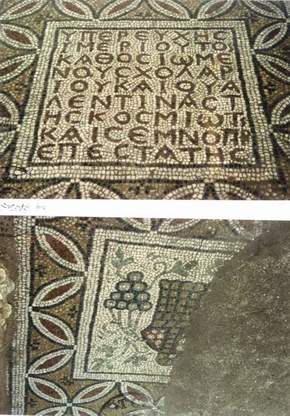
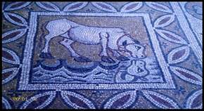
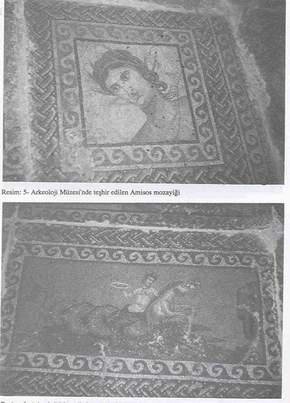
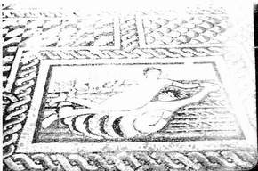
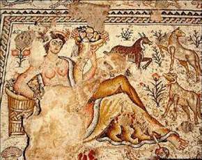
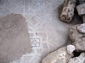
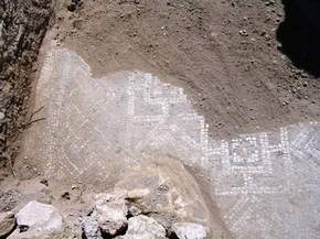
 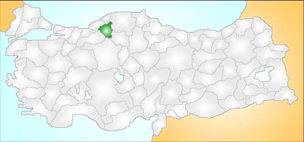 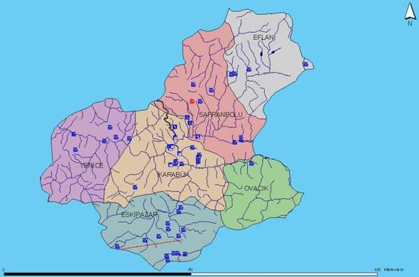 In 2005 an archaeological team from Dokuz Eylül University headed by myself has begun with a field survey project in Paphlagonia where we have chosen Hadrianoupolis as a test area. The aim of this expedition was to enlarge our knowledge about the settlement patterns and material culture of classical Paphlagonian sites. Paphlagonian Hadrianoupolis locates today in modern town center of Eskipazar near Karabük in northwestern Turkey. Geographically it is basically on the borderline of Galatian, Bithynian and Paphlagonian territories. 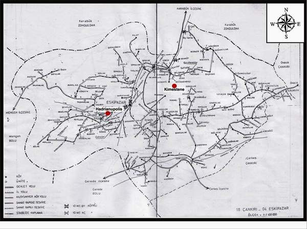 Today the new province of Karabük is located about 200 kilometers north of Ankara and about 100 kilometers south of the Black Sea coast. Thus it is located on the highway between Bartın in Paphlagonia and Ankara which was in ancient times an important route between Amastris on the coast and central Anatolia. It is famous through the railway between Ankara and Zonguldak and also so-called “Karabük Iron and Steel Factory”. 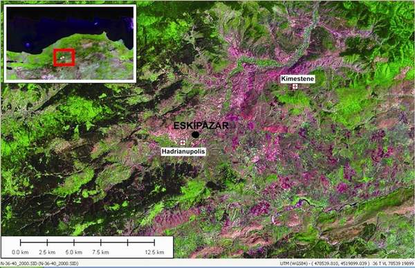 As a central Paphlagonian site Hadrianoupolis has a very interesting geographical position. The location of Hadrianoupolis provides the principal route from the Central Anatolian Plain through the western Black Sea mountain range through Bartın to the Black Sea, a small but important site controlling this major route and dominating a rich agricultural, especially viniculture enclave. Thus it lies on an exact location to transformation of adaptation and change or continuity of culture over time and space, and on the construction of ethnic identities in the multi-cultural area of Paphlagonia. Although Dr R. Matthews from BIAA has recently completed an extensive survey in Paphlagonia our knowledge about Paphlagonia is extremely sparse. 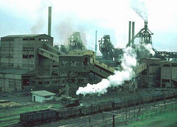 The first sign that a large archaeological site is lying under the earth was when fragments of the mosaic floor of an Early Byzantine church began appearing. The local Archaeological Museum of Ereğli, ancient Heracleia Pontica, began with a small-scaled rescue excavation at this church of Hadrianoupolis in 2003. This church, later called us “Early Byzantine B Church”, situates in the central area of the downtown of Hadrianoupolis and preserved only in its floor and foundation level. 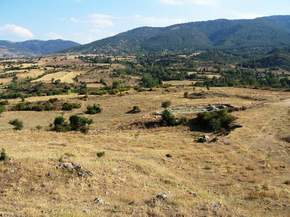 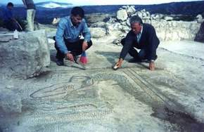 One of the most interesting discovery at the Church B was later burials that not questioned in detail yet. This church was erected probably around the early 6th century A.D., it may have still been in use as late as the 7th century. At the 2003 rescue excavations the ruined 6th century Early Byzantine church B at Hadrianoupolis, arguably this Byzantine city’s most important beneficence church, seemed both relatively well-recorded and unthreatened from a large scrub-covered mound in the north aisle, revealing that it was comprised almost entirely of previously unrecorded Byzantine architectural fragments and sculptures. In 2005 the local Cultural and Tourism Directorate of Karabük has asked to our University whether or not we would like to work in this area and document this church in detail. In response to this kind offer, archaeological field surveys at Hadrianoupolis and its environs, directed by myself was started in August 2005 and will be continued annually until 2010, under the auspices of the Dokuz Eylül University in Izmir, Turkey. When we arrived, these were under direct threat of removal, and were recorded immediately. They presumably derive from the church where they were found, and include what might well be fragments of its marble pulpit and other fittings. With its plan and decoration this church is clearly similar to the one at Çiftlik, near Sinope that was excavated by the BIAA most recently. 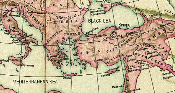 One of the most important discovery at the church is undoubtedly the nicely preserved floor mosaics of early 6th century A.D. On this mosaic various themes of Early Christianity were represented: personifications of four Biblical rivers, 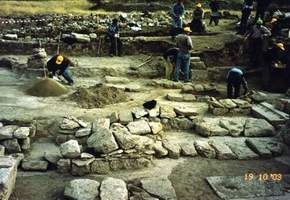 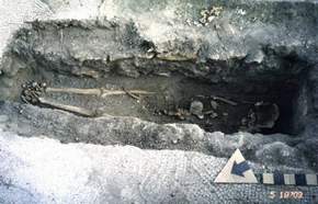 animals, floral and geometric elements as well as an extensive mosaic inscription. 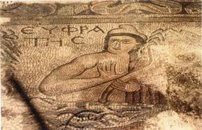 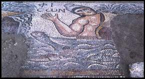 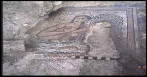 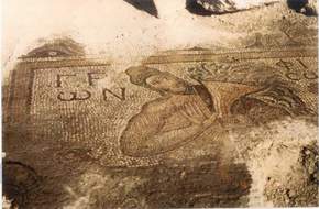 It seems likely to assume that mosaic floors and villas with mosaics were highly popular in Roman and Early Byzantine Paphlagonia, and some of the artists were even coming from southeastern Asia Minor to work on these masterpieces.
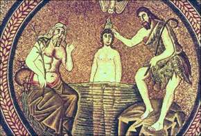
Now the question is the origin of these representations, their date and iconographical details. So far only three examples of Early Byzantine river personifications are known, and none of these from Asia Minor. Henry Maguire mentions in his book a personification of the rivers in the 5th century.
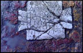
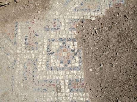
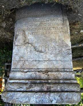
River Jordan is, for instance, personified as an old man with white bear, and drawn in all orthodox icons depicting Baptism. The four rivers of paradise depicted in the mosaic are mentioned in the book of Genesis and also described by Kosmas Indikopleustes (also 6th century) sourcing from a spring or a fountain. Christian river personification should be more surprising at later rather than earlier dates: indeed the perilous, earthly abundance (so easy to turn into decadence) associated with water could be only underlined through personification; Maguire shows how the Nile's waters lost their charm in just a few centuries, with favor shifting to the baptizing waters of Jordan. Since we have another building-inscription of the mosaic as well as a funeral inscription, we can say that this mosaic has established in the first half of the 6th century A.D., parallel to the building of the church. So it is possible to assume that the building was built at the same time with the mosaic. 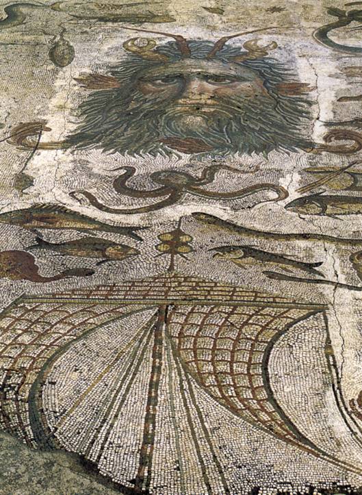 A further discovery at the church was two re-used blocks, each with Roman inscriptions with damnatia memoriae. Since we collect all the epigraphical documents at the site, it is the first time we discover a non-funeral inscription in Hadrianoupolis.
The foundations and architectural elements of two further Early Byzantine buildings were also encountered elsewhere on the site, especially in the north-west corner of the site. 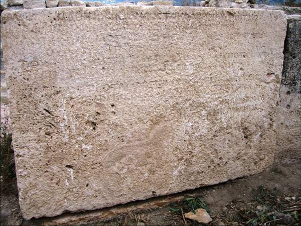 All three of these structures are churches or ecclestiastical buildings and named by ourself as “A”, “B” and “C”. At the Church “A” in a illegally excavated trench a further mosaic floor with simple geometric design has been discovered. These three buildings will be published seperately and will be presented in detail at the Colloquium of German Archaeological Institute in April 2006.
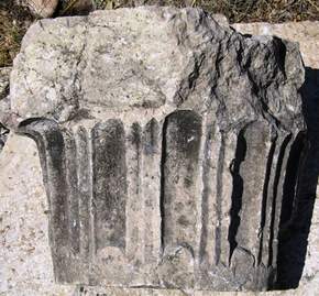
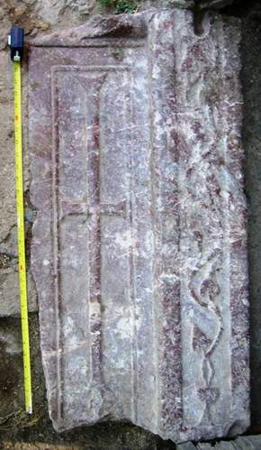
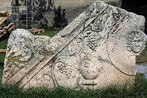
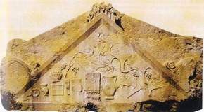
Our further work at Hadrianoupolis was to collect all the rest of archaeological datas, such as re-used architectural elements,
all grave stones and inscriptions,
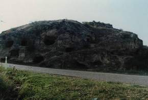
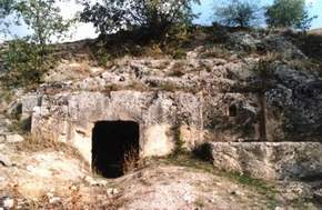
burial sites and
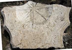
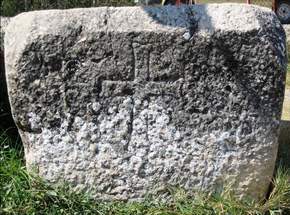
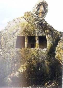
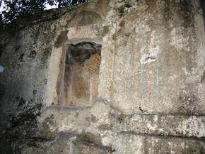
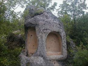
rock-cut niches. One of the most spectacular find of this field season was the discovery and documentation of this rock-cut cultic niche in Hadrianoupolis that was obviously part of a minor open-air sanctuary. Numerous examples of rock-cut cultic niches are known from Paphlagonia so far; but none of them are analyzed in wider extention; therefore, their characteristics, chronology, function and distribution remain as unexplored.
In one of our current study an attempt has been given to understand the monument in detail, and secondly further Paphlagonian cultic niches have discussed through their analogical perspectives with the one at Hadrianoupolis.
In the Archaeological Research Project of Paphlagonia, we first aimed to investigate a wide range of issues centred on long-term human-environment interactions and settlement pattern of southern Paphlagonia. We were especially interested to know what was the role of cities in southern Paphlagonia, and if they were similar to Paphlagonian coastal cities, like Sinope, Heracleia and Amastris. Especially after the detailed survey of Angelika Bittner in Heracleia Pontica it seems that Heracleia have had a general characteristics of a Greek city, like the ones in western and southern Asia Minor. But how was then Hadrianoupolis and other cities in the hinterland of Paphlagonian coast? From our field surveys we came to the conclusion that we have almost no evidence for the Roman Hadrianoupolis, except some inscriptions, rock-cut graves and some cultic areas. In our first field campaign in summer of 2005 we have came to the conclusion that most of the preserved ruins at Hadrianoupolis are from the Early Byzantine period and they consist of ecclesiastical buildings. At the site it was difficult to characterize a classical settlement pattern of a typical Greco-Roman settlement, since settlements are widely distributed in the area and they are far from each other. Thus it was not possible to identify a location as the “center” or “core” of ancient Hadrianoupolis. But where was the Roman city whose name appears on the local inscriptions very frequently. In this way a framework of settlement and land use history, especially for the Classical ages, is constructed for the area of Hadrianoupolis and its close surroundings. Subsequent intensive survey, involving teams of archaeologists walking in systematic manner across sample transects of the landscape, can then fill in much of the detail about particular regions and issues within the overall programme. Using both extensive and intensive survey a total of about 40 archaeological sites have now been identified in this region. Other approaches include study of all relevant documentary sources, and environmental explorations such as stone sources. | ||||||||||||||||||||